
Topographic maps present 3-dimensional landscape on a 2-dimensional surface. These maps are helpful for nearly any outdoor activity, such as hiking, fishing, and of course – hunting. Before I begin to write about using maps and satellite imagery for my elk hunt, I thought it would be helpful to clarify how we read a topographic map and what terrain features can be interpreted from these maps.
The most common topographic maps are USGS 1:24,000 topographic maps, also known as 7.5-minute quadrangles. The USGS has produced over 55,000 maps covering the entire United States. The “1:24,000″ label refers to the map’s scale – every 1″ on the map is equal to 24,000” (2,000′) on the earth’s surface.
In addition to showing natural terrain, most topographic maps also feature symbols and markings for prominent man-made features and boundaries. To fully understand what each type of marking, boundary, and symbol represents – refer to the official USGS Topographic Map Symbols Hadbook (PDF).
Understanding Contour and Elevation
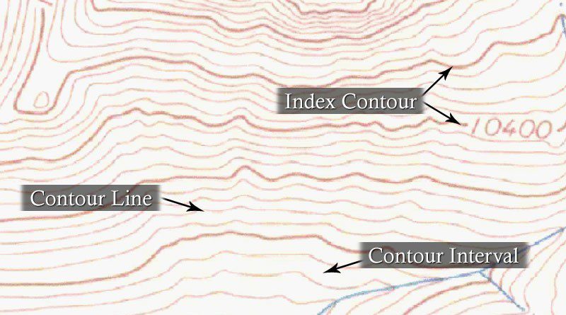
Topographic maps identify terrain and elevation with the use of contour lines. A contour is a line that connects points of equal elevation. So, if you walked along any contour line on a topographic map, you would remain at the same elevation the entire time. However, if you begin to cross contour lines, you gain or lose elevation.
Every fifth contour line on a topographic map is an index contour – a visibly thicker line with a marked elevation. It is important to look at the elevation scale of the map, which can be determined by observing the change in elevation between index contours. On many topographic maps, the change in elevation between any two index contours is 200′.
Finally, the spacing between contour lines determines how steep or gradual the elevation change is in that area. For example, look at the zoomed-in map above and notice the large contour interval at the bottom of the map compared to the very small contour interval at the top-center of the map. This is telling is that the area at the top of the map has a much steeper incline (the contour lines are very close together), and the area at the bottom of the map has a relatively flatter surface (the contour lines are spaced further apart).
Identifying Terrain Features
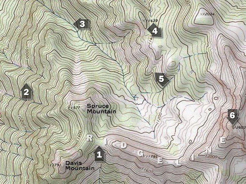
Use the map above to identify the corresponding terrain features below…
A ridgeline is a primary line of high ground, often connecting peaks or hilltops, from which other terrain features originate. For example, a prominent ridgeline can bee seen as you move left from Point #6, towards Point #1, and then the ridgeline slits at a “Y”, towards Spruce Mountain and Davis Mountain. (The ridgeline actually begins far above point #6, outside of this map’s view).
#1 – Saddle – A low point between two areas of higher ground. A saddle is most easily identified as a low spot between two hilltops or peaks, but a saddle can also just be a dip in a ridgeline. If you are in a saddle you have high ground in two opposing directions and low ground in the other two directions. A saddle can often be identified by contour lines that form an hourglass shape.
#2 – Ridge – A long line of sloping ground, with higher elevation in only one direction. If you are standing in a ridge you have low ground falling off two opposing sides, and a high/low line running the other two directions.
#3 – Valley – A long stretch of low lands, commonly formed by waterways, in which three directions have higher ground and one direction has lower ground. Usually two opposing inclines are very apparent, while the opposing high/low line (the incline of the valley “floor”) may be less distinguished; look for the direction of water flow to determine the high/low direction of the valley floor.
#4 – Bench – A bench of isn’t a primary or formal topographical feature, although it is very commonly referenced in hunting. A bench is a flat (or at least comparatively flat) area that exists on the rise of a ridge. A ridge will climb and climb, flatten out to a bench temporarily, and then will continue to climb to the ridge peak. Benches are often found mid-way up a ridge side.
#5 – Draw – A draw or “cut” is similar to a valley, in that it is an area of low ground with higher elevation in only one direction. However, whereas a valley is typically long and parallel to a ridgeline, a draw is commonly smaller, steeper, usually perpendicular to the ridge, and is commonly created by water flow or rockfall. A draw is identified by “U” or “V” shaped cuts perpendicular to a ridge, where the narrow portion of the U/V is pointing to higher elevations.
#5 – Spur – A spur is the opposite of a draw, in that a spur is typically the high ground that is left between to draws or cuts. A spur features “U” or “V” shaped contours where the narrow portion of U/V shape point to lower elevations.
#6 – Hilltop or Peak – A hilltop or peak is an area of high ground where the surrounding ground loses elevation in all directions. Hilltops and peaks can be easily identified on topographic maps by looking for contour lines that form complete, concentric circles.
Topographic Map Resources
Official USGS topographic maps can be ordered in print or digitally downloaded from the USGS Store. There are also several free online resources to view topographic maps; my favorite free mapping sites are CalTopo and ACME Mapper.
Finally, my favorite do-it-all resource for mapping is Hunting GPS Maps. If you want one map resource to show you topographic maps, public- and private-land boundaries, private land owner information, public land types (federal, state, forest, BLM, etc.), access points, trailheads, and more – then you need to check out Hunting GPS Maps. Their products can be used on your computer and in the field via chips that work in hand-held GPS units.
I hope that helps you better understand how you can use topographic maps for your next outdoor adventure! Please check back soon for more discussion on how we can use topographic maps and our knowledge of terrain features to help us locate and hunt the game that we are after.